-
Departments
-
- Departments Accounting Administration Aging and Disability Resource Center Arts & Culture Program Building Services Child Support Circuit Courts Clerk of Courts Coroner Corporation Counsel County Clerk Justice, Diversion, and Support
- Departments DNR Forester District Attorney's Office Emergency Management Environmental Health Extension Sauk County Health Care Center Health Highway Human Services Land Information/GIS Land Resources and Environment Management Information Systems
- Departments Parks and Recreation Personnel Register in Probate Register of Deeds Sheriff's Office Surveyor Treasurer Veterans Service Victim Witness County Directory Social Media Links
-
-
Government
-
- County Board Board Members Meeting & Agendas Video Recordings Committees County Departments County Directory County Ordinances County Social Media Links Building Locations West Square Building Historic Court House Courthouse Annex Law Enforcement Center Health Care Center Highway Shop Human Services (Reedsburg) Parks and Recreation
- Calendar Meetings and Agendas Upcoming Meetings Meeting Videos on Granicus Video Recordings Forms and Documents Forms, Permits, and Applications Documents, Reports, and Presentations Policies Legal Notices/Press Releases Press Releases Legal Notices Foreclosure List Sheriff Incident Reports Open Records Request Sheriff's Dept Records General Records Request
- Voting / Elections MyVote - Polling Locations Register MyVote WI Election Results Bids and Proposals Submitting Bids / Bid Process Current RFPs, RFBs, RFQs State Government State Agencies Hours of Operation Hours
-
-
Community
-
-
Community News
Business / Economic Development Place Plan Start Up Resources Business Financing Chambers of Commerce Registration of Firm Name Creating an LLC Permits Revolving Loan Fund (RLF)/CDBG Persons with Disabilities Apply for Benefits Disability Rights Wisconsin Disability Benefit Specialists Housing Transportation Caregiver Resources Employment Training - Residents Voting Dog License Elected Officials Parks Recycling Renters Libraries Marriage School Districts Severe Weather Shelters Road Conditions DMV Services Sheriff's Incident Reports Online Services List of Online Services GIS Tax Parcel iSite Property Tax Info (ALRS) Pay Clerk of Court Fees
- Homeowner/Property Property Tax Information Property Maps Zoning Information Permits Recycling School Districts Residential Vacation Check Form Foreclosure List Family and Health Nurse-Family Partnership Immunization Program Women Infant Children Parks and Recreation Arts and Culture Libraries School Districts
- Seniors Retirement information Elderly Benefit Specialists Transportation Long Term Care Services Project Lifesaver Caregiver Resources Nutrition & Dining Centers Employment and Training Veterans Federal VA Services State Programs & Services Employment & Education Support Groups Health Care Home Loans Pension Benefits Transportation
-
Community News
-
-
Explore
-
-
ExploreSaukCounty.com
Parks Hemlock Park Lake Redstone Park Man Mound Park North End Boat Landing Sauk County Forest Summer Oaks Boat Landing Timme's Mill Weidman Woods White Mound Park Yellow Thunder Park -
Video Tour of Sauk County
Trails Great Sauk State Trail Hiking Horseback Skiing Snowmobiling Snowshoeing Outdoors & Nature Boat Landings Fishing Hunting Lakes, Rivers & Creeks Local Parks Natural Areas & Public Lands Nature Centers & Conservancies State Parks
Places to Eat & Drink Things to Do Places to Stay
-
ExploreSaukCounty.com
-
-
I Want To…
-
- Apply Marriage License Employment Passport Child Support Public Assistance Food Share Benefits BadgerCare Project Lifesaver Veteran's Benefits Dog License Permits Board of Adjustment Appeal/Zoning Appeal Arts & Culture Grants
- Request Obtain? Birth, Marriage, & Death Certificates Divorce Decree Court Transcripts White Mound Camping Reservation County Park Sticker Transportation Services Hunting Fishing Rec Permits Timber Cutting Permits Vehicle Registration Drinking Water Test Kits Soil Test Kits Pay Court Fees Traffic Tickets Property Taxes Child Support CPZ Fees
- File Divorce Will Deeds Property Liens Small Claims Guardianship Permits Claim for Service Related Disability (Veteran's) Appeal Zoning Ordinances Certified Survey Map Volunteer Aging & Disability UW Extension Parks Land Conservation Neighbor in Need
- Find Agendas and Minutes Property Tax Info Maps Foreclosures Sheriff's Incident Reports Warrant List Sex Offender Registry Zoning Info Voting/Election Info Sanitary/Septic Info Recycling Info Caregiver Relief/Assistance Genealogy Records Vote Register to Vote Polling Places
-
Sauk County GIS Help
Sauk County Tax Parcel Information:
Very basic parcel and tax assessment information, Certified Survey Maps, Subdivisions, Zoning and 2001 Orthophotography. If this is your first time using this site or you are using a dial-up internet connection.
Sauk County Census Information:
Information gathered from the U.S. Census Bureau. Reports on Age, Ancestry, Gender, Housing, Population, etc. are available on this site.
Sauk County GIS Online (Advanced):
Includes everything from the Basic site, plus Soils, Topo's, Shaded Relief, Public Lands, Police/Fire/Ambulance Locations and more. You must have a high-speed internet connection to use this site.
Sauk County Political Boundaries:
Includes School Districts, State Assembly Districts, State Senate Districts, Congressional Districts, Supervisory Districts, Voting Wards, and Polling Places. This site is dial-up user friendly.
Frequently Asked Questions
How do I view the Map?
First, you must download the Autodesk MapGuide Viewer (see link below). This site also has information about the system requirements needed to download the viewer. It is recommended that your screen resolution be set to 1024 X 768 for optimal viewing.
For those using a dial-up internet connection: please exit all other programs and disable pop-up blockers. When you turn on the Township Parcels layer, allow 5 to 10 minutes for the layer to load (and 3 to5 minutes for the City and Village Parcels layer). Once they are loaded, they do not need to reload or refresh, and zooming in and out is fairly quick. Depending upon speed of connection and/or time of day, some features may not work for dial-up users.
What is a layer?
A layer is an entity that is available to view on the map. Layers are like transparencies that can be stacked and viewed at one time, or viewed separately. Here is the list of layers that is displayed next to the map:
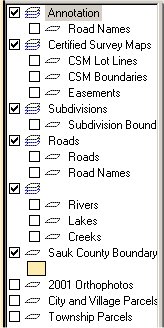
In order to see these entities displayed on the map, you must click the arrow, ![]() and then click in the box next to the layer name you wish to turn on.
and then click in the box next to the layer name you wish to turn on.
What do the different icons mean?
![]() Select. Whether it be selecting layers to turn on or off or using it to click on a parcel to bring up the tax information, this is the tool that you use.
Select. Whether it be selecting layers to turn on or off or using it to click on a parcel to bring up the tax information, this is the tool that you use.
![]() Pan. Moves the map around to display areas that are outside of the current view.
Pan. Moves the map around to display areas that are outside of the current view.
![]() Zoom. Zooms in by a magnification factor of two on the point that you click, or zoom in to the rectangular area you draw with the mouse.
Zoom. Zooms in by a magnification factor of two on the point that you click, or zoom in to the rectangular area you draw with the mouse.
![]() Zoom Out. Zooms out by a magnification factor of two from the point you click to display a larger area of the map.
Zoom Out. Zooms out by a magnification factor of two from the point you click to display a larger area of the map.
![]() Zoom Previous. Returns to the previous zoom magnification and location.
Zoom Previous. Returns to the previous zoom magnification and location.
![]() Unzoom. Zooms out to display the entire map.
Unzoom. Zooms out to display the entire map.
How do I use the Reports and Queries
To use Reports: Click on the square next to Auto Report.
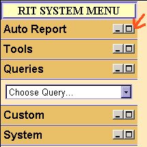
This will allow you to view the pull down menu.
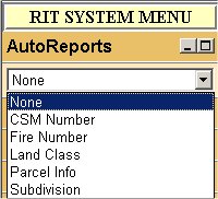
Choose the report you are interested in and be sure that the appropriate layer is turned on (if you are choosing the CSM report, the Certified Survey Maps layer should be turned on). Then click on the entity you wish to have the report on (you must have the pointer arrow on the toolbar selected).
To use Queries: Click on the square next to Queries.
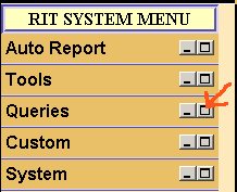
This will allow you to view the pull down menu (see image above in Reports). Choose the Query you are interested in and fill in the blanks according to what you would like to search for.
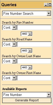
Then hit the "Generate Reports" button and a Report based upon your Query will be returned.
If you would like your report to open in a new window:
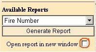
please click the check box next to this option.
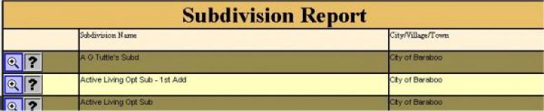
If there is an icon of a magnifying glass within your report, you can click on it and will "zoom" to the Parcel, Certified Survey Map or Subdivision that is listed.
REPORT ICONS:
![]() Zooms directly to the feature listed in the report.
Zooms directly to the feature listed in the report.
![]() Brings you to this Frequently Asked Questions page.
Brings you to this Frequently Asked Questions page.
You can reference this page once inside of the GIS by clicking on the "Help" link on the side menu.
Brief Summary of Reports
Individual Reports
- CSM –Certified Survey Number, name of surveyor, quarter location, section town and range, and municipality (uses Certified Survey Map layer - CSM Boundaries must be turned on).
- Subdivision – Subdivision name, municipality (uses Subdivision layer- Subdivision Boundaries must be turned on).
- Zoning - Name of Zoning District, what Ordinance Number applies and a link to the Zoning Regulations that apply to each District (uses Zoning layer - Zoning must be turned on).
Reports based on City and Village Parcels layer and Town Parcels layer - layer must be turned on.
- Parcel info – Basic assessment information, legal description, owner name and site address and acreage.
- Land Class – Type of land (agriculture, forest, swamp, etc), acreage
- Fire Number - Owner name, fire number, fire district and ambulance district codes.
Why do some parcels show $0.00 for Assessed Values?
The Parcel layer itself reflects the 2004 parcel splits; however, parcels that were new in 2004 have not yet been assessed for 2005. Therefore, there is no value to report and there will not be until November. All assessment values in the Parcel Info report are 2004 data. Tax data for 2005 will be available in 2006.
How do I Print a Report?
After you have generated your report, put your mouse in the report area at the top of the page and and click the "Print this Report" button.
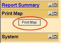
How do I Print a Map?
On the menu bar, click the box next to "Print Map"
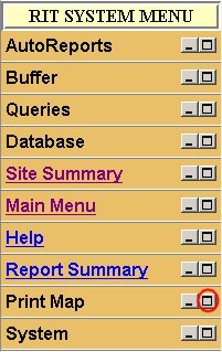
That will open it to show you the Print Map button, click on this button:
This will bring up a Page Setup box.
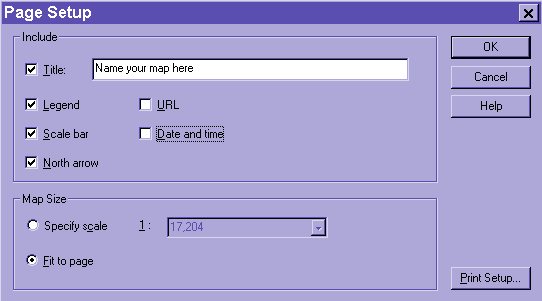
You can name your map whatever you choose, and it will print out as the title. You can choose whether or not to have a legend, north arrow, scale by selecting or de-selecting the check boxes. When you are done with this, you can click on "Print Setup" and choose the paper size and also choose whether you want landscape or portrait. When you have all your settings in place, click 'ok' and the map on your screen will print.
How do I use the Buffer Tool?
Click the square next to Tools. Type in the number of feet (Ft.), miles (Mi.), meters (M.) or kilometers (Km.) for which you wish to draw the buffer. Take the check mark OUT of the box next to "Erase Buffer". Choose the Auto Report you wish to view (if you want a list of owner names within 1 mile of a certain parcel, for example, choose the Parcel Info Report).
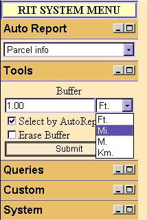
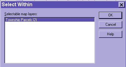
Now click on the parcel that you wish to draw the buffer around (you must have the pointer arrow on the toolbar selected). Click "Submit". You will now see the buffer. Take your mouse within that buffer and right-click. This will bring up a menu. Click Select. Click Within.
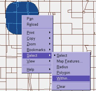
This will bring up another box and click on the Parcels layer. Click "OK". You will now have a report.
Where is the Soils information derived from?
Data in these Reports and Queries are from the Official USDA, Natural Resources Conservation Service (NRCS) soil tabular data digital soil survey. For more information, please see the Wisconsin NRCS site. Or you may contact Carl Wacker, Soil Scientist USDA, NRCS. Phone number 608-662-4422 extension 246
What information is available in your office?
The County Surveyor's records are kept in our office. We have Certified Survey Maps, Plat of Survey Maps, Mortgage Inspections, and Section Corner Tie-Sheets. We also have WPA (Works Projects Administration) records and limited Highway Plans as well as hard copies of 1993 Orthophotography and digital 2001 orthophotography. The Tax Parcel maps that we produce are kept in the Treasurer's Office, although they are also housed on this website (See the Mapping Home Page). We now also house the Flood Plain Maps produced by FEMA.
Where do I go for additional information?
- Tax Parcel Maps are located in the Treasurer's Office.
- Topographical Maps are in the Planning & Zoning Department.
- Zoning and Fire Sign Maps are also in the Planning & Zoning Department.]
- Soils information is available in the Land Conservation Department.
- Older Aerial Photography (pre-1993) is available at the NRCS office.
- Orthophoto's of smaller areas than the 4-section photo's in our office are available in the Farm Services Agency.